Hillforts - A fan site
.
Sometimes you have to press enter/ return key, on your keyboard on the address bar to go to a page after you pressed on it's link.

I have to admit all the pictures on this page of hillforts are mine, and almost all the picture of sites are in North Wales, Though I try to bring more of the rest of Wales into this page's writing, as is vital to the story of these fortifications in the country
So anyhow, Wales has been called, the "land of castles", with this title well deserved as it numbers over six hundred. Though it could just as easily be labelled a "land of hillforts", as there are even more hillforts in Wales than castles. Indeed some when including structures that are almost as small as defended farmsteads, say there are 1,000 in the principality.
It is the land, as it is where I live, where I have seen more hillforts than anywhere else.
With below some pictures of some of ones I have been by or on.
The hillforts of Wales cover the map of this region probably more than any other piece of the two largest islands of the British Isles. This is as England has some areas, a small amount really, which are simply too flat, and lacking in hills for anything that could really be called a hillfort. Though it has promontory forts in some of those areas, they are only able to be on the coast in many of those cases. Then for Cornwall, there is a mildly similar situation, where coastal forts are key as of it's long coastline. With for Ireland, large areas being covered or by lakes, and such flatter lands, mean it actually has areas which are more likely to have a crannog than a hillfort. While for Scotland, as well as also possessing it's fair share of lakes or lochs, and also isles, which sometimes do and sometimes do not have a good amount of hillforts. Also a reverse situation occurs, where some areas such like the Grampian Mountain areas, have the mountain ranges too high for settlement at that latitude in big numbers, causing a massive gap in hillforts distribution accordingly.
Anyhow, Wales, had these hillforts right from the Bronze Age to the Iron Age. In this Iron Age era there were some great hillforts, including the one at Dyserth in North Wales, Moel Hiraddug, a hillfort I have been to more than I have been to any other. Plus Castell Henllys in Pembrokeshire, South West Wales, which was turned into a great site for experimental archaeology, and thus has had Iron Age roundhouses sitting within it, since the 1990s, and a Iron Age style entrance in some senses. So to any hillfort fan, a great site to have visited.
Indeed, no corner of Wales escapes, from having a good fort in it's vicinity, from Anglesey's Caer y Twr, right up in the North West tip, to right across North Wales, and through Mid Wales. For instance the site of Gaer Fawr, near Welshpool in Mid Wales, which sits covered in trees upon a hill, elevated in the middle of the grassy farmland of other forested tufts of hills and plateau of the area. Here a boar figurine was found from the Iron Age, that likely would have been attached to a Warrior's helmet. Evoking brilliant scenes of artwork, and military pride and bravado. It had a story of starting as a summit fort, then expanded with a annex into almost six hectares. Surely a dominant force in the landscape at the time.
There is also a fine one overlooking the coastal town of Aberystwyth, Pen Dinas, like a crows nest on a hill overlooking it. Whose history like so many has been estimated at after excavations. Indeed it has seen signs of rebuilding of entrances and redesigns across it's long Iron Age history, and other examination. Some speculate fire damage indicates there was a raid in the middle of the Iron Age, but others wonder if it just indicates a accident. With finds indicating pottery, and even glass beads traded all the way from Meare Lake village, a Iron Age Glastonbury lake Village style location in Somerset.
With of course many more dotting the South West Wales counties profusely.
They also spread in patches all the way to South East Wales, with them being of big numbers among the legendary though true, Silures of South East Wales. Who as a loose tribal confederacy used their tactics and geography to hold off entire Roman Legions, where much wealthier and bigger kingdoms to the east had as of their geography been less able to do so. Indeed at the Roman site of Caerleon a hillfort sits on a hill overlooking the site.
These hundreds of forts led a variety of different tribal confederations, across many hillforts and settlements. A great many as in England went out of use in the Roman era, when Wales saw Roman forts on some scale in every corner of the land. Indeed Caerleon's Roman fort in South East Wales, and Chester just over the border from North East Wales, in North West England, are 2 of the finest Roman sites in Britain where thousands and thousands of people would have lived. This is a testimony to the ancient Britons to the Romans, as for instance Iberia only needed 1 Roman Legion to keep a hold of it. Though it was more so according to experts, in the case of Chester, to watch out for rebellions in Northern England, the former Brigantes territory that happened into the 2nd Century AD. Plus to protect off forces from Caledonian Scotland, that were a greater security risk to Rome as the empire consolidated itself in the southern half of Britain that it held, .
Caerwent a walled town, also in South East Wales, was a site for the native tribe the Silures who it is said, were moved from their many disparate hillforts, to a more Roman style of society. Partly this was Roman force, a policy of their’s to Romanise the natives of their territories, and Romanise them and make them self sustaining areas, so thus less taxing on Rome's resources. Plus partly surely economic pressures caused may Silures to accept this choice. In fact it's walls today are still high, and many remnants of Rome turn up in the soil. Sites like Llanmellin Wood hillfort nearby thus became unimportant, and likely even unused. It must be said though that Wales, saw a small number of forts survive in terms of use, especially in areas further from the main Roman sites. Indeed most experts claim Rome may have let the native people of the land, do their own thing to a extent, as long as they gave some form of resources to Rome, and did not rebel. As shown by how most of the empire, like Iberia except for the Basques, Gaul, and Italy, even Romania, saw a form of "vulgar" Latin develop into the Romance languages of today even for the common people. It is possible that eastern England, was becoming Latin speaking before the Saxons arrived, but for the rest of Britain, except for the large Roman towns, that was not so. In Wales and Cornwall the Brythonic Celtic language remained and developed into Welsh and Cornish. Well in North Wales Penmaenmawr's Braich Y Dinas hillfort, and a number of others saw plenty of use during the Roman era. In fact Wales's greatest surviving fort, Tre'r Ceiri, one of the highest hillforts in Wales, and among the most populous and best preserved, and in terms of preservation, in Britain as a whole. Well, it had it's peak during the Roman era. I must add today Braich Y Dinasis gone, replaced by a quarry, which is tragic, considering it was likely as brilliant as Tre'r Ceiri. These forts must have been Celtic culture sites, that had come to a agreement with Rome, to allow their ways to a extent. Despite how Roman roads known as the "Sarn Helen", named after a semi-mythical wife of a Romantisised British linked Roman Emperor, cris-crossed Wales, as much as much of the rest if Roman Britannia. Rraching to Holyhead's trade with Ireland, and the gold mines of Dolacouthi in the South West, past small forts like Caerhun in North Wales on the Conwy's lower stretches.
After Rome fell, hillforts saw a boost across the island of Britain, as Roman towns lost access to the economy that helped make them sustainable. Over the border in Western England hillforts saw a modest boom, never as much as their Iron Age peak, but still a very noticeable one. Plus also Wales saw a growth in their numbers in parts where they had become a thing of the past. Such as at Dinas Powys in Glamorgan, which took many months to build, and then became a redoubt for what must have been elites, with pottery even of Mediterranean imports, and metal working. This site lasted till the 7th Century, so a couple of centuries, ending when state building in England and Wales seems to have made hillforts less of a choice for elites. In the very connected to North Wales at the time, Eddisbury in Cheshire, along it's northern ridge, there was also reoccupation after the Romans, by it's post-Roman, Britons.
Across what I still like to call the Dark Ages, there were occurrences where hillfort style settlements were in use. From the north to the south of Wales. There were other more lowland, court sites, and such used as well, but perhaps that was something that occurred in the Iron Age as well.
North Wales' Rhos on Sea, in the Dark Ages, had Bryn Euryn. The fort may have been a base of a character criticised by the 6th Century monk, Gildas, known as Cynlas the Red, “the rider of a chariot, which is the receptacle of the bear”. The bear being the surely by that description, either a bear-like angry persona, or maybe a barrel chested political strongman figure. Many claim this to be the case, as part of the area round there was traditionally known as Din-erth, which is likely a mutation from Fort of the bear. Excavations here, revealed a Dark Ages fort atop of the hill, with limestone walls 10 foot high, and the ramparts 11 foot wide.
Foel Fenlli, on the Clwydian Hills, which was also reoccupied, had a powerful figure like this, who major Christian leaders of the time in the period after Rome, who came to Britain were not fans of.
In the second millennium and as the Middle Ages wore on, hillfort sites were supplanted by castles across Wales. In some cases, old hillfort sites were still used. As most spectacularly above North East Wales's Llangollen, where unusually a castle is built right on the crest of a hill, way above the local town, so it's castle ruins are visible for miles around like a romantic Victorian painting. This is actually where the old hillfort had been. Many castles were built on traditional hillfort sites, or sites like that, but more usually ones, that were close to water sources and such. I mean hillfort sites seem in the Iron Age to have often not been that bothered about sieges as the armies of that time were more temporary, and had to go back home to farm. There were some sites that look like they could survive sieges, but most not. Castles in medieval warfare were more usually built by lowland town sites, or rivers, or other water sources. So many more were built in new locations. After all it was likely always the case, that some settlement sites were far from a suitable hillfort site, and Iron Age people would just have to accept that. Though in the days of a castle, a structure could be built with many of the features of a hillfort, and more convenience for either the rulers or the people. I mean sometimes like in the traditional view of Norman occupation, just for the oppressive ruler's convenience. Anyhow, as time wore on, even castles were to be replaced by mansions and palaces, for the elite, and towns and cities for the mass of the population, and so like hillforts, in many cases, castles often became ruins. Which is why today so many castles are partially damaged, and almost all remaining hillforts, grown over. Though both are well commemorated by historical societies, and great efforts are made to keep them known, researched, recorded and protected. Though there has been the odd annoyance, such as a few castles and hillforts destroyed by building or quarrying. Sometimes this is a inevitable part of human life, after all we can not live in cotton wool, or wrap every piece of land up unused for ever, but sometimes no doubt it is a travesty for greed, and on the whole, even after looking at the profit and loss account economically, a undeniable net loss for humanity as a whole. So here is hoping these hillforts are protected as much as they can be, while keeping with other concerns for people, and nature, but let's hope so.
Hillforts must have been noted even when unused by Medieval people, but in the 18th and 19th Centuries began to be mentioned more for writings by antiquarians and such. For Wales, figures such as Thomas Pennant at Tre'r Ceiri wrote descriptions that brought them to a wider attention that just their previous semi quasi custodians, the local populace. With in later days, top archaeologists from places like the Universities of Wales, from Cardiff, to Newport, to Bangor, Lampeter, and Swansea, to Wrexham's Glyndwr, and some from outside Wales, like Oxford and Liverpool and such like getting more and more facts on the sites.
P.S the Welsh hillforts, get a good lot of mentions in my story which you can buy of course, Well I have more pictures below, and also some descriptions of the photos. I have read the Welsh fort hillforts is bryniau. So Bryniau yn Gymraeg. But they may have been called Caer, in many cases the Welsh for a fortification area kind of thing
So here is a paragraph on hillforts in Welsh,
Mae gan Gymru gymaint o gaerau bryniau'r filltir, ag unrhyw ran arall o Ynysoedd Prydain, efallai mwy. Y bryn bryn mwyaf yng Nghymru Penycloddiau, sef rhai darlleniadau y mwyaf ym Mhrydain.
WEBpages on hillforts


Welsh Hillforts
The pictures on this website are listed and described below. So I can tell you that they are top to bottom, with left to right where they are aside each other. All the pictures on this page were from me, so you need my permission to use them.
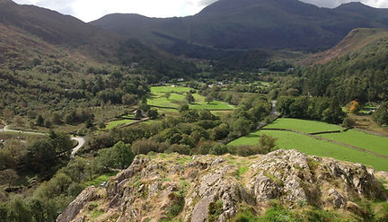
So the top picture is from Caer Drewyn Hillfort, a Iron Age fort. From this vaulted position you look down on the inland Denbighshire, North Wales town, of Corwen, from the ancient walls of this structure. These structures dropped out of use in terms of being actual hillforts, by the post 1066 Middle Ages, in the main, but there were 2 occasions when Welsh princes, launched counter offensives against the invading crown of England, from these sites. Once when Owain Gwynedd massed troops against the invading Henry the second of England in the 12th Century. Then most recently Owain Glyndwr in the early fifteenth century used this as a early assembly point for his huge revolt against the penal laws on Wales, and for his attempt to be a ruling native Prince of Wales. Though it was sites like the English built Harlech Castle, and his own raids, that were of more use to his tactics and hold of territory by that time. Though it does show a folk memory related to hillforts, even to a figure as late in the Welsh story, as he himself.
The next picture, is one taken by me of Dinas Dinlle, a lovely site on the North West coast, really just on a large natural mound, that was gently touched or moulded by people centuries ago, into a defensive bastion. It is quite a little walk up and down, but at 30 metres high, shorter in relative height than even Oswestry hillfort. Despite that from the top you see across the flat expanse, to the hills of Snowdonia, and as you could suppose it has some good views up and down the coastline as well. Indeed the area is so flat it has Caernarfon’s small local airport not far away. From here I flew on a tourist flight, from which you can see the high mountains, Anglesey and Caernarfon from above. Today the fort is named as Dinas means city in Welsh, and in older Welsh was more about it being a kind of settlement on a smaller scale than modern cities. The rest is after a figure from the Mabinogion. Which was a collated work of the medieval myths of Wales, which I talk of later. He is Lleu, or Lleu Llaw Gyffes, who it talks of having supposedly magical conditional invulnerability, and sleight of hand, of turning into an eagle and all sorts of things. That figure is supposedly based on a Pre-Christian, Celtic Dark Ages figure, likely known as Lugh in Ireland, and Lugus in Gaul,
I have also placed a public domain picture from Wikimedia Commons of Caerleon's amphitheatre, to show a fort outside of North Wales, yes it is a Roman site, but that was important to Wales and it's hillforts. All the other pictures on this page are by me. Caerleon means, fort of the legion, it is a mutation of that term, and Caerwent not that far from here, is a mutation of the Roman name, Venta Silurum, or market place of the Silures. Both Caerwent and Caerleon may have had up to 10,000 people living in their Roman era peaks, and Roman remains still dominated the towns for years. With indeed Caerleon famed for its still standing bath houses, and walls, to the time of Geoffrey of Monmouth, a Celtic Breton, of Norman culture, who wrote the Norman version of King Arthur collated from Welsh and Breton myths. The Baths thought by him and others to be ancient palaces, with him also surely impressed by the still standing very tall tetra pylon monument of the Romans, seen for miles around, into this era. With additionally also it's Roman bridge surviving till after these structures had fallen, and been robbed of their stones into the Middle Ages as well. Showing its glorious position in this time, such a primer for an imagination of a writer like him.
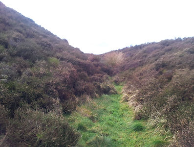
Then below is the site of Penycloddiau. This is one of the forts that sit on the Clwydian Range, a line of hills that cut north to south in North East Wales, that many see as among the natural landscapes that help form Wales into what is still a existing cultural unit. It rises to 440 metres above sea level, a height that many of the such forts are on this range. So this large Iron Age site, here well you are looking at the northern ramparts, a few of them amid the heather. Amazing to think these were once great sites of human occupation, but now sites clad in heather and grass. The phrase heather and hillforts is actually used to promote the walks here, and there was some kind of book written on this nature.
Then by there, is a picture from Deganwy Castle, down towards the North Wales coastal town of Deganwy which is near Llandudno.
So below it is another picture, I have used Microsoft paint to create my interpretation of what a fort called Black Rocks fort, or Castell Tremlyd. I have seen better ones than what I have made of it. Though I am proud of what I have done here. The Deganwy Castle, which has a pic below is not normally listed as a hillfort, but I regard it as able to be seen as one. After all it was a Dark Ages Welsh princes' site, before it was at times a Welsh and sometimes English held castle. Surely the Dark Ages site would have resembled a hillfort. Castell Tremlyd, as late as the 17th Century was a remains of a fort on many maps, possibly similar to Dinas Dinlle, one of my fave forts, that sits by the North West Wales coast. The normal effects of coastal erosion overtime have almost completely destroyed it, other than possibly some rocks, left from the former peninsula. Though even then I say it can be classed with hillforts, as a lost site. Whether it was Celtic, or Roman, or even later than that is uncertain, but it still was once a important site for the land, of some unknown time. It is a reminder of that Welsh myth, of Llys Helyg, of a coastal kingdom or settlement destroyed by the sea, a myth from the Middle Ages, and of course things like this must have occurred in the past to some small extent. Legends like this crop up the world over, such as to do with Cornwall's legends to do with King Arthur, which I mention in my hillforts.co.uk page on St Michael's Mount. So like that English port in the east, Dunwich that was buried by the sea, after everybody had left, int he Middle Ages, which had before then been a major port of the Anglo-Saxons.
To their bottom left is a view looking towards Snowdonia, from the Lleyn Peninsula. The hill this was taken from, looks over Tre'r Ceiri, possibly Wales's finest fort. This fort is among Wales's highest and sits above a pass that leads into the Lleyn or Llyn,, with it a great site celebrated by antiquarians of old. Then under it, is a view towards it from Dinas Dinlle. This coastal fort, sits as a lump on a coastal plain, and you may see the beach below, which indicates how the sea is eroding away the natural foundations of this site. Though when you look south you see the Lleyn Peninsula, and a number of peaks, along what is North Wales's most western mainland extremity. The glorious thing about these peaks, is they are capped in many cases by hillforts, which must have seemed like cities in the sky, including that site of Tre'r Ceiri. These forts have remains of kinds of kind of rubble wall roundhouses, which you do not really see so much in many other sites outside of here, they seem to be a quite local kind cultural thing. I do not mean roundhouses, they are pan-British, but this kind of variety of them. Tre'r Ceiri is actually called City of the giants, when translated into English from Welsh, and you would guess the people in these sites must have been a powerful group to command such centres, not giants obviously, but powers.
The picture to the right is of Foel Fenlli, sometimes called Moel Fenlli, itself a good long walk away from Penycloddiau, and a similar height. I have again put hillforts and a rampart around, to imagine a fort site. Again it is nice to think that where there was once heather there were once hillfort dwellers. It also would look over the Clwydian valley, maybe for protecting, or maybe for power.
Under it is a view from the Dark Ages site of Beddgelert's Dinas Emrys. This site associated with myths like dragons, is built on a kind of dragon shaped jagged hill, and would have been a formidable defence site, partly as of it's natural gradient.
Then to the right, we have Deganwy Castle, this site mentioned earlier, is a site on 2 shapes of hill, like what you see from this picture, with one on the other side, hidden from view by the other. I say it's Dark Ages version can be termed a hillfort. It was the main site of this area till the building of Conwy Castle by the English in the 14th Century.
Under there to the left is is Foel Fenlli in the distance from the land below in Spring or Summer. To the right is Dyserth's hillfort of Moel Hiraddug. This site has seen it's northern portion destroyed and used for quarrying, but I still like it, as there are still remains, and I have been here far more times than to any other fort. On it, from the valley floor, you in Summer can see white kind of hairlines, on a sunny day, which are collapsed rubble walls, which I believe are the remains of former more imposing walls. From a distance those white lines, you can imagine what these walls, must have looked like when built, as from a distance they would be as much of a same shape as now, not up close though. This fort is on the northern end of the Clwydian Hills, and did protect or hold passes, and ancient routes among other things, indeed it is near the Gop. The Gop I should mention is a ancient Prehistoric Neolithic structure, the second largest manmade mound from that era in Britain, after Silbury Hill in Wiltshire. It is from a older Neolithic era, and it sits across visible from the top of the fort, on a hill over a number of fields on the route east from the fort. Well such monuments are often built on what were then major routes, like this one that pass past north of Dyserth's Moel Hiraddug fort. I think it is fair to say Rhuddlan Castle to the west along this route, which was built to control the lowest crossing ford of the River Clwyd, may have supplanted Dyserth's fort. You see the fort dominated the route that passed north of it, that headed east to the rest of North East Wales. Important as in those days, a coastal route was not a good option as of all the marshes there at the time.
Then below to the left some heather covered ramparts and ditches on Moel Arthur, a pinnacle of a hillfort, that to me seems like a guard post guarding a narrow pass in the Clwydian Hills. I like it as it is so much of a crow's nest site above the pass, and it can be seen as a shape as far away as Beeston Castle in Cheshire, which also was once a hillfort. Then to the right of there is a view from Penycloddiau, looking North West at the Clwydian Valley below.
Then under there, 2 pictures by me again, and again you need my permission to use these pictures. So my reckoning of a look of what Dyserth's hillfort may have looked like in the Iron Age, and below a picture of how even the hill itself has been attacked by quarrying, and what it looks like now. I like this rendering by me, it is not as good in any sense as some of the ones done by historical organisations and state bodies, but it is a nice effort. Then underneath them a picture of Dyserth's fort from the south, and how it overlooks the Clwyd estuary, surely the area it protected and whose it's leaders held sway over, and where my story's starting place just is. Well to the left of there, Abergele, Castell Cawr, and a example of ancient hillfort walls, grown over by trees, showing the ancientness of these structures.


Then the last group of pictures are to show Penycloddiau. So first of all a picture by me, so you need permission to use it, probably could not without money as I am fond of the work I did on it. Well from the North Wales coast, or Clwyd Estuary I have labelled where the forts are on a line 20 miles long. I am not sure if those labels come out, but you can know the one that is second furthest right would be Foel Fenlli. ( I also have it in my book, on one of the many parts) Then a picture from Moel Y Gaer, Rhosesmor, seeing Penycloddiau and Moel Arthur, then from near Denbigh, of those 2. Then a pic seeing the view south from Foel Fenlli. Then Moel Arthur from Moel Y Gaer again. Then a picture of the model of a boar found at Gaer Fawr near Welshpool. Plus a tiny miniature of the fort scape itself. OK a last pic, back to where we started, but a change of weather from the top of the page picture, Caer Drewyn Hillfort towards Corwen in the rain.


Sometimes you have to press enter/ return key, on your keyboard on the address bar to go to a page after you pressed on it.