Hillforts - A fan site
.
Sometimes you have to press enter/ return key, on your keyboard on the address bar to go to a page after you pressed on it's link.

Other
Iron
Age
structures

The Iron Age and it's wonder, had the amazing element of Hillforts. This was not all that existed in Britain and Ireland though. The isles also had a number of other fascinating sites that added to the variety of everything around here.
1 As the Iron Age began to draw to a close in Britain, and was replaced in many parts by a new Roman era, just before then, there were proto-towns developing. Many in fact became Roman towns, such as the modern site of St Albans, and also Chichester. It seems this process had been incoming since before fifty five BC when Caesar invaded the South Eastern corner of Britain. By the time of the Roman invasion by Claudius from 43 AD, then this was a situation where in cases hillforts in parts of the South East of England, had been superseded as a main base, by walled small oppida. This was suited to these areas seeing they were flatter, and less hilly, not that any county in that area has no hills, but the new style settlements suited a new style of society. One that was for instance seeing coinage start to be minted at greater levels in this region of Britain, and most importantly greater trade with Rome’s possessions, so affecting the economy and culture down here. Indeed these proto towns of these sizes were not to occur in most of the rest of Britain in big numbers till Rome came in. It has to be said, before then, across Britain some hillforts were of a size in population that could be termed proto towns. Plus from Aberdeen to Carmarthen at the very least there were likely settlements that were on lower ground at key strategic locations, though which in all likelihood were either enclosed, or in many cases in open unenclosed settlements. Most of those sites were more villages at best than proto towns though. It is also likely ports such as Exeter, a term from the Roman Isca, had a level of proto town population before Rome, partly as of all the blossoming continental trade they had.
It should also be added there were in addition to this, villages, hamlets, homesteads and isolated roundhouses for sure, across much of Britain. With some of these being more open, or more defended settlements, and some more common in some regions than others. Such as villages more common in parts of southern England for instance.
2 Brochs were a structure that were a entirely Scottish creation. These structures were at their commonest and greatest in Northern Scotland, such as the great broch at Mousa in the Shetland Islands. These 10 to fifty foot tall towers were used by surely chiefs and warlords, to protect their lands against intruders, with populations fleeing to them in times of need, and actually living around them during more peaceful times.
Most imagine the societies to have been similar to the Highland clans relationships between the people and the chiefs, though it is possible, they were even more communal a form of leadership than that, or more oppressive like Norman castles, though it debatable.
Mousa, the tallest pre historic inhabitable structure in the British Isles, stands 44 foot tall, and is the only broch to be almost complete at the top, likely as the structure was at it's commonest up in the north, like in Caithness, the Western isles, and the Northern Isles, of Shetland and Orkney.
Inside there were stairways heading right up to the top. The areas below were sometimes walled round below as well. It is great to think there was this broch society up in Northern Scotland, with some elements stretching south. With them living their lives with the same in many ways elements of Celtic lifestyle as the rest of Britain, except in some areas of the far north, with even windier winters.
They seem to have been built on the whole from 100BC to 200AD, and there are five hundred in Scotland. Some were used on and off by later groups, and such, even Vikings and Highland Clans. In a extremely rare case Dun Ringill, on Skye, a broch given the honour of being the name for a 1970s Jethro Tull song was used into the 19th Century. Though I am unsure if that one was still a recognisable broch by then, indeed it is also listed as a hillfort site.
If you call the Iron Age, the land of hillforts, then Brochs were a mighty sub culture strongly related to the era. With families, and communities living in them through Summer days, and dark dramatic brooding winter nights. Usually living normal everyday lives but sometimes in times of crisis fearing the next raid, or even planning a revenge raid.
I read in my edition of British archaeology, July 2005, that it ,may have taken a year to construct them, and there was high praise for the architects and builders, in expertise at building from the internal staircase, and tactics in repelling water.
There was another attempt in Caithness, and I read in my British Archaeology Journal or magazine from 2007 that they built and destroyed a broch just to see what they could work out from it, what has or did happen to brochs that have been crumbling though staying remakbly intact for about two millennia.
Scotland later on in the Iron Age, while Rome led the rest of Britain, also had Wheelhouses and Atlantic roundhouses especially on the west coast. These wheelhouses were structures that were stone, and from above would resemble a wheel, with cells, on the outer curve right the way round. They were likely ritual sites.
The Atlantic roundhouses were again as the name indicates a Western seaboard, occurrence. Their remains are now like the remains of many stone houses foundations, without the tall walls, they used to have, which often sit along and hidden in the terrain of western coastlines.
They seem to have been quite large and complex at times, and in typical traditional Highland fashion to have had often turf roofs. Some were in protected rings, and were the centres of in the larger more complex cases, many families. The term cellular building suits for some of them.
There were also Duns, which were kind of a cross between a mini broch and a roundhouse, again these are commoner in the west of Scotland. Again these were Iron Age structures, so a real flowering of independent invention in this era.
3 Crannogs, another sub culture of this time these beautiful structures were common among the lakes, lochs, loughs, and llynnau of Scotland and Ireland, with famously one in Wales. These manmade islands, with often palisaded protected villages upon them were at their commonest in Ireland. Indeed there would of been times when during the Hillfort era, when tens of thousands were living the crannog lifestyle. Protected by a natural moat as a lake of sorts, and living in protection, able to paddle away to the shore with the reflection of the clouds above, and back again. These structures actually existed way before the Iron Age, in the Bronze Age, possibly even in the Neolithic. Plus they lasted after even the British Roman era, especially in Ireland. Indeed some were around to a extent in the later invasions by Elizabethan, Stuart, and Cromwellian England (which at times involved Scotland). Though it has to be said gunpowder by then was becoming a match in both definitions of that term, for them.
Before gunpowder, they were brilliant defences in the flatter lake lands of Ireland, and parts of Scotland, just too far away for a attacker to reach. After the cannons, they were sitting ducks, especially as they were also banned for a while to a extent.
Some say that the Irish myths indicate some of the huts were decorated with bird feathers, and it is certainly the case these would be lovely sites at times, such as on a nice Spring or Summer day, idyllic even.
Again the typical Celtic culture was what was often occurring on these islets. So indeed most crannogs were quite so manmade islets, and some were extended with wooden platforms, and stilts, so they could be more roomy sites.
The Crannog on Loch Ness, Cherry Island, is almost surprising as famously Loch Ness is a deep long cavern, the deepest loch in Britain, but it sits on the south west, rim, at a point where there is less of a immediate drop, and also the water level was risen as of the Caledonian Canal, needing access, so it is the only crannog the Loch has, while Lough Neagh has seven. Loch Lomond has a crannog called the Kitchen. Some say Loch Tay has between 18 and 20, of which the majority are submerged all year.
It must be said, though not a crannog there were some fine equivalents in Iron Age England. Indeed the Glastonbury Lake Village of the Iron Age, a site that existed before then was a site of hundreds of people, sitting protectively in those wetlands. A place where likely pelicans, would have been and many a water fowl. The site was a major location, with trade and goods passing through, with the site surrounded by water at some wetter parts of the year, and drier swamp, with causeways at other times. Wooden causeways have been found here and in Ireland, but some in Ireland may have been for ritual depositing of items in bogs, whereas here they were often surely for travel at for instance Glastonbury. Indeed those lake villages in and around Glasto' were in cases sites of glass beads production of sorts, great tools, and all kinds of the apparel or paraphernalia of a thriving lifestyle.
The Celts were great users of these sites, but the Polish culture of the time, called Lusatian, in the middle of modern Poland, included what could be called almost a super crannog. This Iron Age era site, Biskupin was enormous and had many long houses, and was a centre of riverine trade. The site contained 1000 people in this Venice of the Iron Age, without the canals.
The Irish Gaelic for crannog is crannóg, and Scottish Gaelic crannag.
4 Dykes, often a defensive ditch with a palisade beside it, were in existence. Indeed the idea of a dyke, commoner in England under the Anglo Saxons has existed for hundreds of years before then. The idea of a ditch and rampart to slow attackers, and mark a boundary existed on a scale often in Southern England, but also in other parts of the British Isles.
Indeed there is a belief in the Black Pig Dyke in Ireland that seemed to separate Ulster from the rest of Ireland. In legend a giant pig created the boundary with it's tusks. It cuts ancient Ulster off from the south in tandem with forests and hills. It has been dated to the 4th Century BC. The best explanation I know of, is it was to protect off cattle raiding, indeed in larger parts there seems to have been palisades protecting the ditches.
Also there were dykes in Iron Age England, not as long as the later Offa's Dyke, but the south east had some marking boundaries, or helping defences. Some were from the Bronze Age, but some reached as much as 14 miles long. It is interesting that in later times they were called Grim's ditches, a association of them to less Christian times. Perhaps they had been associated to Pre Christian gods, and therefore were associated to the antagonistic figures in Christianity.
There is a over 20 km long one in upland Ayrshire, which may be ancient, but it is uncertain what it was from. The major speculation is it was to separate upland and lowland communities, a theme that crops up as a theory in prehistory, that was more common a theory in earlier decades than now. Maybe this was a stronger difference then, and the idea does not come into our heads in nowadays.
It must be said a proto town where St Albans is near, Wheathampstead has a Devil's Dyke, a small part of the area protecting or marking a area of 40 hectares, (a hectare is about the size of a football pitch) this a site which may have been attacked by the Romans in fifties BC. This site was superseded as Celtic site by St Albans Celtic site, and was likely a centre of the Catuvellauni tribe.
5 Ports, there were undoubtedly harbours and ports. Indeed Iron Age harbour facilities have been found near Poole in Southern England, that likely were used for the trade between Britain and continental Europe in the Iron Age. It is the case that in times of low tide despite the area having a higher sea level now, that archaeologists have boated out to them and stood on the ancient jetties, something that can not be done in the rest of the year. I believe I saw this on Time team or some such programme. It has been dated to the third century BC, and was over 80 metres long, and just 1 of 2.
Hengistbury Head, and another number of sites here were also sites where Roman trade was strong.
Trade had been going on for centuries, indeed boats have been found in Yorkshire that could travel round Britain in the Bronze Age, for just cross British as well as European trade. Though here it is possible Brittany and their Armorica in part of the Iron Age dominated cross channel trade.
Cornwall likely used the trade of Armorican vessels, to trade tin, to the continent, and onto through France and Marseille. There were smaller trade sites, but that can be talked of in my story.
The theory for Brittany substantiated by written sources is that there were small isles, that were causewayed and thus on land at low tide. That would have cargoes loaded onto ships at low tide, and then they be sent north to Britain by the incoming sea at high tide. Possibly at sites looking like Saint Michael's Mount, or maybe a proto town like Exeter, on the mouth of the river, that led from the metal sources of the Dartmoor hills.
Experts state, that sources such as Strabo the Roman writer and other things indicate Britain exported it's own people as slaves, tin, hunting dogs, cattle, hides, read baskets and more. While in return, Britain received amphorae of wine, and other luxury goods, and the tiniest elements of the trappings of booming Roman civilisation. This kind of trade may or may not have driven the economic growth of Northern Europe, as Poland sent amber south, and Gaul it's own stuff as well.
Six. Mines, were a feature of British life even before the Iron Age. Indeed the copper mines of the Bronze age, at Llandudno, North Wales, were well used, and Cornish tin was used before then as well. Salt Mining seems to have been occurring in Cheshire even before the Romans, for this great resource, that was so important it could be traded over 30 miles.
There is debate if lead was being exploited in Flintshire, North East Wales as well.
7 Fogous or Souterrains were underground manmade caverns, likely used to store food, for to keep it safe from going off, and also from raiders. Cornwall and much of northern Scotland have a lot of them. The first of the terms is Cornish in origin, the second Scottish, though of course it seems terms for them from a later time. Likely they could also be used as bolt holes. Though it must be said wells and springs existed, and in some cases manmade wells, or shafts even in forts which may have in some northern Scottish forts like Burghead have had ritual importance, and connections to the mythical underworld.
8 Transport would have in the main for these self sufficient people, have been far less needed than in nowadays. Also till the 19th Century, sea travel was a better way of getting round Britain, than land travel.
Though, there were times land travel was the best option, even across the country. There were well travelled routes, such as the Ridgeway, from Wiltshire to the Thames, often just patches of well trodden ground, where floods and swamps and hills could be avoided as of lie of the land. The thing is, in cases hillforts tower over some of these routes, and in cases they were so ancient you notice a strong amount of Neolithic monuments on some obvious ancient routes.
Sometimes they would form into proper paths, developed by chariots and wagons, and people walking along, and it would lovely to think the odd resting place, tavern or shop would be at some, even at a hillfort, though that may be a step too far to prove.
Most brilliantly the roads actually had continuity abounding. Indeed this is indicated by this. Many of the routes today such as the M1 motorway the first motorway in Britain, from London to Leeds, and the A9, between Perthshire, up through Cairngorms, it's high hills on either side to the Highlands, are still routes today that were major routes in the Dark Ages. This is shown by how the Ridgeway is dotted by major hillforts, and the A9, and how many major battles were fought on either end of such ancient routes that are still key today. It is the case that not all major roads today follow such routes as of draining certain previous obstacles, and building through mountains, in great achievements, Which has made sites like Rhuddlan castle, or such not the place where so much travel went by as they did in times past. Though it is the case some still are, and this was from before the Iron Age. Indeed look how close Stonehenge is to a major motorway in Southern England, as a example. Indicating sometimes great sites were positioned near key ancient routes. Making hillforts on them, of key importance in those times.
It is great to think, druids, armies, traders, merchants, minstrels and more travelled these routes in times past.
Many locals routes were like sheep paths or footpaths, some were patches of flat ground, and some surely formed into roads. A very small amount were wooden trackways, or paved. As I say though a great route to take was rivers, as well as the coast, by boat.
9 There were of course ancient structures from previous eras, such as Stonehenge, and such, which were as seemingly ancient to many a Iron Age Celt, as they are to us now, and in most cases it seems not used anymore in the Iron Age. Though some such as Newgrange in Ireland were certainly still being used for Iron Age traditions despite being built in previous millennia. Likely not in the exact same way as their Neolithic builders intended, but similar surely ritual ways. It may be the continuity there was as it was such a large site, or possibly the population had more continuity.
Though sometimes it may have been the case that Celts of the time would adapt them to their legends, for instance the Bretons adapted stories about Merlin to do with their immense amount of standing stones. Also, and some in different parts of Britain to the modern era have legends, or characters associated to them.
The belief is that the massive change in Britain from Beaker people migrations were possibly a reason why the Celts who they got most of their heritage from were not using the Neolithic structures in great numbers. Though both must have had fairly organised, druidic or priestly faiths, along with common folk beliefs. How much the Beaker people replaced the Neolithic people, or the Mesolithic people, who they replaced is unsure, but for certain elements of both populations survived in the Celtic population. Indeed some say they were stronger the more north and west you went, like how the Celts were stronger in such a way after the Anglo Saxon incoming, and there was even some regrowth of the old Neolithic DNA in parts of southern England in parts of the Iron Age. So surely elements of their Neolithic cultures survived a little in the Celtic era. It may both times have been as the south east, is flatter, so while that large fertile area will have a big population and be closer top rich European cultures, so often the richer part of Britain, once a force took it, it was easy for them to take all of it. Then they would meet up with the more difficult, more upland, west and north, just as the Saxons and Romans, came up against.
Language often seems to be something that when it starts being replaced can go quite quickly but religion seem to have elements that often last longer, so possibly elements of the Celtic faith in Britain were from Neolithic times. Though we do not know much about it, so this is all guesswork. It would be nice to think even elements of the Mesolithic culture survived from then, though nonsense to say it certainly did. It would be surprising if the Basques with their older history did not keep some elements of interaction between their Neolithic ancestors and the Mesolithic people they absorbed.
Some say, a great theory, that there were 4 known massive waves of migration into the British Isles before the Norman conquest of England.
Firstly the Hunter gatherers, then the farmers in the Neolithic, who over time absorbed the hunter gatherers, then the Beaker People, then the Saxons. It seems the Romans, had a surprisingly small effect in terms if migration, and there may have been other ones in the Celtic era of small effects, like whoever brought Le Tene and Hallstatt cultures in but that may have been by osmosis. Then also the arrival of Belgae migrants into South East England, which may have been large, and certainly occurred just before Rome arrived.
Then also, there is a fifth really, the Vikings, who had big effects in the north and east, and coastal areas.
It may be that DNA evidence looking at Anglo Saxon immigration in the Dark Ages, may be counting Belgae immigration from half a millennia earlier, or Saxon immigration during late Rome, in their totals, but that is just a theory.
Also, there were of course mixing and migrations, between the different parts of Britain, and small arrivals, of a trader or a mercenary from Europe, or even beyond, from the time of Rome, or even the time before. This would be lost in the DNA stats by now, but must of happened in small ways.
10 Religious and ritual sites still existed though many were likely within roundhouses in or near hillforts. There are indications of what they worshipped from the Irish myths, and continuing traditions mentioned and recorded in the 19th and 18th Centuries. Some see a site at Navan or Emain Macha in Ulster, and it's huge roundhouse, or structures like it elsewhere as a likely temple, More so, seeing the fort is inverted, the ramparts face inwards which some feel indicates the site was a ritual site for spectators not defence. Some also feel this about Uffington Castle Hillfort, seeing it is so close to the Uffington Horse.
Many think, the way that the early Christians across Europe and the world used many Pagan sites as religious sites, from wells, to others, indicates that many Christian sites are built on Pagan sites. Possibly indeed the Roman temples of Britain may have been grabbing Celtic religion’s sites, as conquerors often do. So many churches may be on old Pagan temples, as a sign of Christian domination over the old Pagan gods. The fact that many Christian churches have ancient yew trees and such in them could be some sign as that, in taking Pagan appropriation of nature into their religion, as by accident into their’s, or it could just be that yew trees in churches are so well protected as a coincidence of being in graveyards, and thus last a long time. Examples include, Llangernyw, and Overton on Dee in North Wales. It is the case though that Holy wells, and such did crop up in Christian traditions, after appearing in Pagan ones and the one in Holywell, Flintshire, has a tradition of a head, coming back to life, and there are some ideas that heads were important in some Celtic faiths, though again maybe a total coincidence.
11 Ireland also had raths and ringforts.
I mean a good description of a rath would be, like a motte and bailey castle, with a ditch on the outside, with the mound far shorter, and inside it a hollow bit where the roundhouse was inside. Plus with a kind of entrance going straight through everything, with palisades on either side of it, so not as big as a hillfort, but still intimidating enough to be as if like a hedgehog’s spines. Maybe big enough to make predators choose another target. They could also keep maybe 2 to 3 roundhouses cramped in together, and even their cattle. Some had stone roundhouses inside rather than wattle and daub, which makes sense, as if you are stuck there why not build it as good as you can.
Ringforts, are small often low lying forts, enclosed by circles of banks, and sometimes stone, or wooden stake palisades. They often have space for just 2 or 3 roundhuts. They existed in big numbers in Ireland possibly upto 50,000, and in very much smaller numbers in west Wales and Cornwall.
Amazingly 60,000 raths have been spotted in Ireland to 2018, protecting the modern Irish diaspora of todays’ then ancestors, not including the ones who had not arrived there yet of course. Though most of those in due time have or will mix with these, so that statement in still true for them too. The west of Ireland had more stone-type, than just the earthen ones of east. I must also state the rath, is also felt to have been to protect livestock against wolves that only went extinct in Ireland in the 18th Century. Indeed some used to wonder if hillforts were partly to defend livestock from these predators, though most say, they were mostly to defend from other people.
So I must say, there are over 100,000 raths and ringforts in Ireland. Of which many today have nothing noticeable remaining. Some of them were so round and small though, that in cases trees and bushes have been left to grow over them, amongst grassy fields. These noticeable circular yet natural looking features, have old traditions of them being fairy forts, and habits linked to them like for childless couples to visit them, for luck with procreation, surviving to today. Brilliantly Ireland’s most well marketed fairy, the leprechaun, the little bearded green clothed, gold miser-ing, mischief makers are associated to them too. Though that fairy only has a small amount of associations with the Dark Ages Irish myths, and was more a medieval and later character, bit of fun for stories. Though it speaks of the Iron Age beliefs I say, that it was shoehorned into later folklore, and legends in such a continuance way.
One of the best excavated of these, it larger than most, with unlike many, still surviving stone rubble built walls, actually a small hillfort to most. Was the 15 metres wide, very circular stone ramparts, Rathgall in Leinster, dating from 1200-900BC. Actually it had many items found in it by Barry Rafferty and his excavation team. Finds in the site, partly as of it later being an overgrown greenery covered burial site, include glass, ceramics, and best of all so tying in with the myths to with the little people, gold items. So just like how they were supposed to have gold at the end of the rainbow, though only in myths, but funny how the legends can associate with them to such forts.
Raths started dying out fastly around 900AD.
12 Other structures include the fact, that bridges have found in the Thames from the Iron Age, and also grain pits, and posts which likely indicate grain held up by structures and stored there. Indeed also the chariot burials of Yorkshire where likely elites were buried with horses and chariots. Plus the horrific ritual sites of bogs where bodies have been found, preserved indicating what they ate and died of. Though that is a disturbing subject in some ways, best I leave that, and certain more gruesome elements of Celtic culture out. Not that funerary practices are gruesome, its just something I do not want to dwell on, as I feel when people talk about the gruesome elements of the Celts it seems like the Roman propaganda view of them, when it gets in the way of seeing the nice things about their culture. As all cultures had horrid stuff, and it is not fair to denigrate and ignore a whole culture as of that, it is best to abhor those elements, oppose the bad bits strenuously, and such.
So Chariots and wagons, could be counted as well indeed the Romans mentioned their warriors being able to work in unison, in groups of huge numbers of the wheeled sprinting vehicles, so they must have been a site to behold. More so, as the Gauls were now using cavalry, like Rome.
There were many other things as well, so but that is all I can say for now. Like there is a site in Anglesey where in a small lake, lots of Iron Age goods have been found, again likely a site for depositing newish items to the Celtic underworld. There is a site like that in South Wales coalfield as well.
Then of course there were many a hamlet, homestead, and especially villages in the south and east, some were open, and some undefended, indeed it may have been that most people lived in such sites.
Also there were was more countryside, more forest more of that sort of amazingness.
There are some more pictures below
.

THE WEBpages on hillforts


Now are the explaining of these pictures on this page,
So firstly the Broch of Mousa, in the Shetland Islands, a public domain picture I got off Wikimedia Commons. Then the remains in a picture myself took, so you need my permission to use it, of a stone structured roundhouse from a Iron Age Village on Holy Island, near Holyhead, part of Anglesey / Ynys Mon, in North Wales. Then to the right a wikimedia commons picture of a Iron Age trackway from a a similar time in Germany, not that Celtic, but Celtic sites had trackways like this often for sites like Glastonbury Lake Village. Or in Ireland, like at Corlea Trackway, where they seem to have been trackways for people to walk down to lay deposits to the Celtic underworld.
To the below there, is a Glastonbury Lake Village landing stage by Forestier 1911.jpg English: A representation by A. Forestier of the landing stage at Glastonbury Lake Village from 1911, and from Wikimedia Commons Public domain,
Then to lower left a picture by me, so you need my permission to use it is of the Loughbrickland Crannóg from the side, not public domain, my pic. This is in Northern Ireland. I have a very poor picture of Cherry island, Loch Ness, on my Scottish geography quiz page, but at least it is a rare photo showing how small the islet is compared to the rest of the loch, it seems crannogs can look larger from land, than from the water. It is known as Eilean Muireach, meanin Murdoch's Island, in Gaelic.
Then to lower right, I believe public domain, attacks on crannogs 1602 in the Kingdom of England's attack on the Irish of Ulster, contemporary depiction, I think public domain, correct me if it is not public domain, but is wikimedia commons.
Then under that, my picture, so you need my permission to use it, of Torwoodlee, in Southern Scotland, near Galashiels, broch's remains. A rarity for such a structure to be so far south, and a example of how many were ruined by use of the stone for other structures. Likely Mousa, was protected by it carrying on in use, and being on a isle.
Then to lower left a public domain depiction Lake_dwelling 1886 drawing regarding Ireland, also from Wikimedia Commons,
Then to the right a public domain picture of Wheeler's wall, Stanwick Iron Age public domain, a iron age site, a near oppidum in Northern England.
Then right at the bottom is a depiction of Glastonbury Lake Village, Representation_of_Glastonbury_Lake_Village_by_A._Forestier.jpg (286 × 400 pixels, file size: 45 KB, MIME type: image/jpeg) a public domain picture from Wikimedia Commons.
Ok, seeing you insist, one last picture, it is a picture I took, of Chichester Tow walls, so you need my permission to use it, Yes they are later but they stem from a Iron Age proto town, on this site a Celtic capital, of a tribe that would have had much of Sussex. Then were expanded into by Rome.
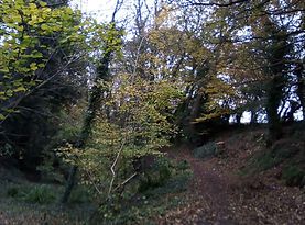
OK seeing you insist one very very last picture for this page, it is of Wat's Dyke, in Holywell. There is a path, but to it's right the remnants of a remains of a dyke from the Dark Ages, it is in North East Wales. Such dykes would have been commoner in Saxon locales, and indeed this one was of their heritage. There were some in Southern England in these Iron Age eras specially guarding urbanising centres on flat plains. To an extent it was kind of a northern tip of Offa’s Dyke.